BEDWYN BOUNDS
Volume II Chapters
Volume II Chapters
- Little Bedwyn Parish
- Bica's Bedwyn
- Earl Wulfgar's will
- The Reforms of St. Aethelwold
- The Bounds of Bedwyn and Burbage
Bica's Bedwyn
This volume describes the territory of Bedwyn, which was first recorded in a Saxon charter of 778. The interpretation of this document is particularly challenging as much of it has been damaged, and the surviving description of bounds is written in Latin and Old English. The charter defines a large area of land, which was separated from the Bedwyn estate, and granted to a man called Bica. Several historians have compared the suspected boundaries of Bica's estate with the modern parish bounds of Little Bedwyn.
In 778, Cynewulf, described as king of the West Saxons, granted 13 hides of land to Bica, one of the prominent members of the local aristocracy. The award of land, believed to be Little Bedwyn, is recorded in one of the earliest known Saxon charters. However the actually document may be more recent, and may have been a copy made at Bedwyn in the tenth century. In the page image, you should be able to recognise the text "cymenes denu". This text is part of the first boundary clause, and 'Cymens valley' refers to the elongated dry valley which begins at Newtown and descends, via Stype, towards the Bedwyn stream at Froxfield below the Pelican inn. For further information on Saxon charters, consult the Electronic Sawyer.
Earl Wulfgar
The division of large royal estates provided family and retainers with endowments and rewards during the final century of the Saxon period. A example of local estate division is illustrated by the early tenth century will of Wulfgar, who held estates in Kintbury, Ham, Collingbourne, and Buttermere. The contents of the will demonstrate not only the division of estates by the crown, but also the intention of of Ealr Wulfgar to distribute his estates among several family members and the church. The donation of land to the church indicates a concern for the afterlife, which provided an important motivation for ecclesiastical benefactors throughout the mediaeval period.
The division of large royal estates provided family and retainers with endowments and rewards during the final century of the Saxon period. A example of local estate division is illustrated by the early tenth century will of Wulfgar, who held estates in Kintbury, Ham, Collingbourne, and Buttermere. The contents of the will demonstrate not only the division of estates by the crown, but also the intention of of Ealr Wulfgar to distribute his estates among several family members and the church. The donation of land to the church indicates a concern for the afterlife, which provided an important motivation for ecclesiastical benefactors throughout the mediaeval period.
Edgar and the reforms of St. Aethelwold
In the tenth century, king Edgar granted the royal estate of Bedwyn to Abingdon abbey in a series of charters dated between 961 and 968. The various endowments received by the abbey relate to the Benedictine reform movement, which king Edgar energetically supported. The charters provide an incomplete description of the boundaries, which have confused local historians for many years, and probably will continue to do so for many more. The award of the Bedwyn estate was short-lived, for it was recovered by the crown during the short and tragic reign of king Edward [975 - 978]. Significantly Burbage was returned to the crown but remained permanently detached from Bedwyn, and a parish, containing a church with a small ecclesiastical estate, and three manorial estates, was established before 1066.
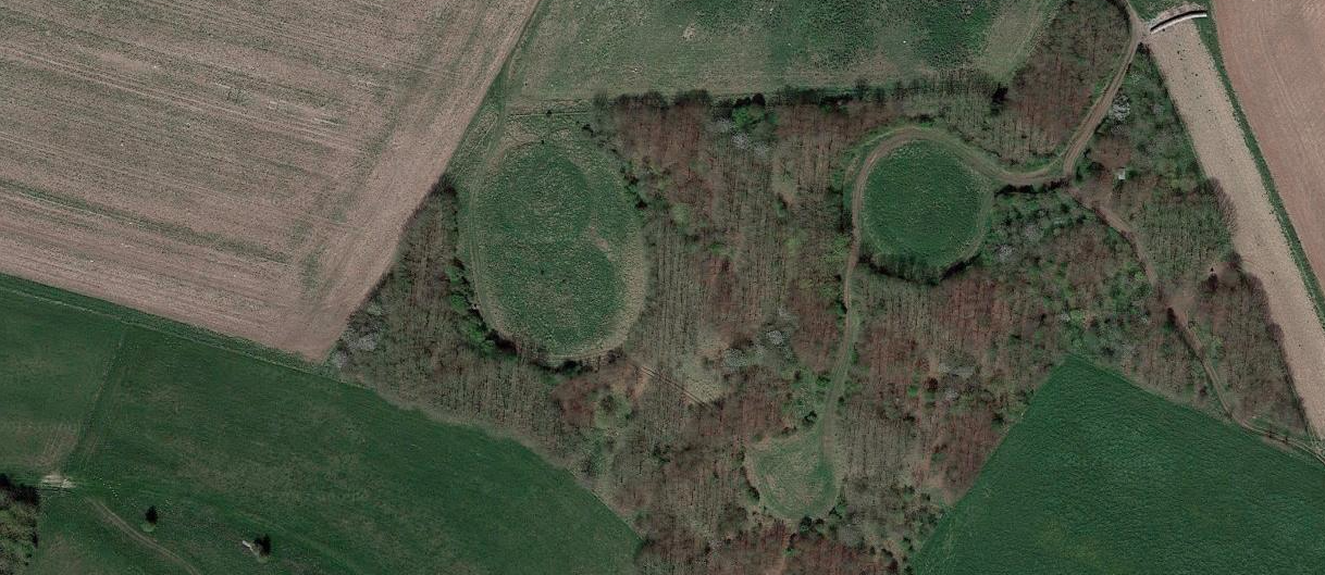
Google Map: Hooked Barrow, two interlinked barrows below Wexcombe down, a unique boundary marker
The Domesday Book
The reorganisation of Burbage was part of a ongoing reformation of land tenure and agriculture, which extended far beyond the bounds of Bedwyn. The Domesday book of 1086 reveals the substantial division of the eleventh century Bedwyn estate, with the creation of 15 estates between 978 and 1066. Additional estates were to be created in Bedwyn and Burbage during the mediaeval period, and this process of division continued into the Tudor period.
The reorganisation of Burbage was part of a ongoing reformation of land tenure and agriculture, which extended far beyond the bounds of Bedwyn. The Domesday book of 1086 reveals the substantial division of the eleventh century Bedwyn estate, with the creation of 15 estates between 978 and 1066. Additional estates were to be created in Bedwyn and Burbage during the mediaeval period, and this process of division continued into the Tudor period.
Tracing the Boundaries
There has been a recent trend among some historians to see a continuity in territorial boundaries from the Roman to the Saxon periods. There is no local evidence to support this view. Furthermore, the evidence of the Bedwyn charters suggest very little continuity between the Saxon and modern period. It must also be noted that few of the Bedwyn bounds are defined. Despite the pioneer work of O.G.S. Crawford, very little is known about the original Saxon boundaries. Furthermore, Bedwyn may appear to be a quiet little backwater, but its boundaries have been subjected to constant change over the last two thousand years.
In the mediaeval period, two new parishes, Froxfield and Little Bedwyn, were created. However, there have been more changes in local parish boundaries in the last 150 years than in the preceding 1,000 years. It is now impossible to map modern Ordnance Survey parish boundaries onto local Saxon charter boundaries. The parish of Grafton was established in 1844 after the division of Great Bedwyn parish. The formation of Grafton parish led to the definition of new bounds, for which the Kennet and Avon canal, and the route of the Winchester Roman road served a convenient purpose.
Twelve years later in 1856, land again was removed from Great Bedwyn parish, when the parish of Tidcombe and Fosbury was created. Ironically many modern parish boundaries in Bedwyn are now less than 200 years old. These Victorian parishes were created in response to population increase, and in the desire to ensure sufficient places of Anglican worship. They were accompanied by an enthusiastic building program, which resulted in new churches such as East Grafton, and in the modification, or restoration of existing buildings. The most recent parish is Savernake, which was created in 1934. Subsequent boundary changes have occurred increasingly in the name of local government reorganisations, often without any obvious reason
Boundaries were traditionally maintained by annual perambulations which were conducted at Rogation tide. Adherents of the Reformation considered it to be popish, although George Herbert, writing in the early sixteenth century, was able to write enthusiastically on the subject:
Particularly, he loves Procession, and maintains it, because there are contained therein four manifest advantages. First, a blessing of God for the fruits of the field: Secondly, justice in the Preservation of bounds: Thirdly, Charity in loving walking, and neighbourly accompanying one another, with reconciling of differences at that time, if there be any: Fourthly, Mercy in time is, or ought to be used. Wherefore he exacts of all to be present at the perambulation, and those that withdraw, and sever themselves from it, he mislikes, and reproves as uncharitable, and unneighbourly [The Parson's Condescending by George Herbert]
The publication of Ordnance Survey maps has made this tradition redundant, but it is happily preserved in many parts of the country. The parishioners of Ramsbury and Axford have been regularly walking some 24 miles of boundary for the last fifteen years. The Savernake Team Benefice usually conducts a Rogation tide service at a local farm.
Downloads
Bedwyn Bounds files are available Easter 2021
Bedwyn Bounds files are available Easter 2021
